|
 Re: Merry Smitemas!
[Re: Alaskan_TA]
#397622
Re: Merry Smitemas!
[Re: Alaskan_TA]
#397622
12/29/10 01:51 AM
12/29/10 01:51 AM
|
Joined: Jan 2003
Posts: 104,346
Garden Grove, CA
OzHemi

Penguin-hating Ginger
|
Penguin-hating Ginger
Joined: Jan 2003
Posts: 104,346
Garden Grove, CA
|
  Orange County Coastal Areas (1 Alert ) Special Weather Statement Issued by The National Weather Servicee ...WINTER STORM TO IMPACT SOUTHWEST CALIFORNIA LATE TONIGHT AND WEDNESDAY FOLLOWED BY VERY COLD WEATHER... A STRONG STORM APPROACHING FROM THE NORTHWEST WILL MOVE THROUGH LATE TONIGHT AND WEDNESDAY MORNING WITH SHOWERS LINGERING THROUGH WEDNESDAY EVENING. THIS FAST MOVING SYSTEM SHOULD TAP INTO DEEP MOISTURE RESULTING IN A PERIOD OF MODERATE TO HEAVY PRECIPITATION WITH THE FRONTAL PASSAGE WEDNESDAY MORNING. RAINFALL TOTALS SHOULD RANGE FROM ABOUT A THIRD TO TWO THIRDS OF AN INCH IN THE COASTAL AND VALLEYS AREAS WITH NEAR AN INCH ON THE COASTAL MOUNTAIN SLOPES. HOWEVER...THERE COULD BE LOCAL LARGER AMOUNTS ON THE SOUTHWEST FACING SLOPES OF THE SAN BERNARDINO COUNTY MOUNTAINS. THE HIGH DESERTS SHOULD GET UP TO HALF AN INCH OF RAIN WITH LESS THAN A QUARTER OF AN INCH IN THE LOWER DESERTS. THE ADDITIONAL RAINFALL WILL CAUSE RAPID RUNOFF AND FLOODING DUE TO NEARLY SATURATED GROUND FROM RECENT RAIN. THIS COULD RESULT IN FLOODING OF LOW LYING AREAS. THERE COULD BE DEBRIS FLOWS IN AND BELOW RECENTLY BURNED AREAS AS WELL AS ROCK AND MUD SLIDES ON STEEP TERRAIN...AND FURTHER EROSION OF RAIN SOAKED HILLSIDES. THE SNOW LEVEL WILL BE NEAR 7000 FEET THROUGH MOST OF THE STORM...THEN FALL TO 6000 FEET BY WEDNESDAY AFTERNOON AND TO 3000 FEET OR LOWER WITH A FEW LINGERING SHOWERS. HOWEVER...MOST OF THE WIDESPREAD SIGNIFICANT PRECIPITATION WILL BE OVER BY THE TIME THE SNOW LEVEL LOWERS...AND ANY SNOWFALL ACCUMULATIONS WILL BE VERY SMALL BELOW 5000 FEET. SAN BERNARDINO COUNTY MOUNTAIN RESORT LEVELS AND THE HIGHER RIVERSIDE COUNTY MOUNTAINS SHOULD RECEIVE ABOUT 3 TO 8 INCHES OF SNOW. HOWEVER...ABOVE 7000 FEET MORE THAN A FOOT OF SNOW CAN BE EXPECTED. THE HIGHER SAN DIEGO COUNTY MOUNTAINS COULD GET AN INCH OR TWO OF SNOW. COLD AIR DAMMING ON THE NORTH SIDE OF THE SAN BERNARDINO MOUNTAINS COULD RESULT IN SNOW FLURRIES IN THE HIGH DESERTS AS WELL WEDNESDAY NIGHT. STRONG GUSTY WEST TO NORTHWEST WINDS WILL ACCOMPANY THIS SYSTEM...BECOMING EVEN STRONGER BEHIND THE FRONT WEDNESDAY NIGHT. THE STRONGEST WINDS WILL BE IN THE MOUNTAINS AND HIGH DESERTS WHERE THERE COULD BE WIND GUSTS OVER 65 MPH. THESE WINDS COULD CAUSE BROKEN TREE LIMBS...DOWNED TREES AND DOWNED POWER LINES. NEAR ZERO VISIBILITY WILL BE POSSIBLE AT TIMES DUE TO SNOW AND BLOWING SNOW. DRY COLD NORTHWEST FLOW ALOFT WILL BRING TEMPERATURES ABOUT 10 TO 20 DEGREES BELOW SEASONAL AVERAGES THURSDAY AND FRIDAY. THERE WILL LIKELY BE WIDESPREAD FROST IN THE INLAND VALLEYS THURSDAY AND FRIDAY NIGHTS. PEOPLE TRAVELING LATE TUESDAY AND WEDNESDAY SHOULD CLOSELY MONITOR THE LATEST NATIONAL WEATHER SERVICE FORECASTS AND STATEMENTS AND PLAN ACCORDINGLY. THE RAIN WILL CAUSE SLICK ROADS AND MOTORISTS SHOULD USE EXTRA CAUTION. DO NOT DRIVE THROUGH FLOODED AREAS OR AROUND BARRICADES. IF TRAVELING INTO THE MOUNTAINS...BE PREPARED FOR THE POSSIBILITY OF WINTER STORM CONDITIONS WITH VERY LOW WIND CHILL TEMPERATURES.
|
|
|
Re: Merry Smitemas!
[Re: DirectSubjection]
#397631
12/29/10 03:28 PM
12/29/10 03:28 PM
|
Joined: Jan 2003
Posts: 104,346
Garden Grove, CA
OzHemi
Penguin-hating Ginger
|
Penguin-hating Ginger
Joined: Jan 2003
Posts: 104,346
Garden Grove, CA
|
Quote:
Quote:
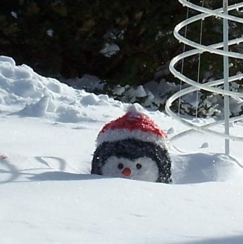
Oh, and is he still buried as deep as in the picture?  
No, I dug them out a bit after that. 
I am sure they appriciate the better view. 
And no need for a shovel here today....but a bucket might come in handy 
|
|
|
 Re: Merry Smitemas!
[Re: DirectSubjection]
#397633
Re: Merry Smitemas!
[Re: DirectSubjection]
#397633
12/29/10 10:32 PM
12/29/10 10:32 PM
|
Joined: Nov 2005
Posts: 15,126
85086
moparpollack
Lil Herman
|
Lil Herman
Joined: Nov 2005
Posts: 15,126
85086
|
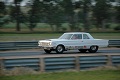
 Now we need an action shot at Barry's house! 
56 Plaza 63 D100 step side 67 Coronet, 68 Roadrunner, 69 Super Bees, 69 Coronet 500 convertible, 70 Roadrunner Post, 79 D150 360, and a severe case of Mopar a,d,d
|
|
|
|
|


 I just fold mine up and stick it in my pocket.
